Over the last few years, we’ve assisted thousands of drone pilots in passing their Aeronautical Knowledge Test to get an FAA Part 107 Remote Pilot Certificate.
And in that time — we’ve learned a lot about what topics our students struggle with 🙂
This may come as no surprise to those of you who have already started studying, but the three areas our students are challenged by most are:
- Effects of Weather (Density Altitude, Thunderstorms, Temperature Inversion, etc.)
- Weather Reports (METAR and TAF reports)
- Reading Sectional Charts (Airspace, Latitude / Longitude, etc.)
Taking a look through our database of nearly 350 practice questions, below are the 13 that jump out and can hopefully give you an idea as to the kind of trickery the FAA has up their sleeve.
Many questions reference Figures that you’ll need to look up in the FAA’s testing supplement to properly answer the question. Here’s a link to download / open the testing supplement (168MB, PDF).
1. Which thunderstorm lifecycle stage is mostly characterized by downdrafts?
A) Cumulus
B) Dissipating
C) Mature
The correct answer is Dissipating. There’s a LOT of information in the Effects of Weather on Small UAS lecture. Make sure you go through this lecture one more time if you’re missing any rote memorization questions like this. Wind shear, density altitude, temperature inversion, the different types of fog…these are all concepts you can be tested on.
2. An aircraft announces, “left downwind for runway one six”. This means that the aircraft is on a heading of:
A) 80 degrees
B) 160 degrees
C) 340 degrees
This question tests your understanding of runway orientation and normal aircraft traffic patterns. On Runway 16, aircraft will be taking off and landing toward 160 degrees.
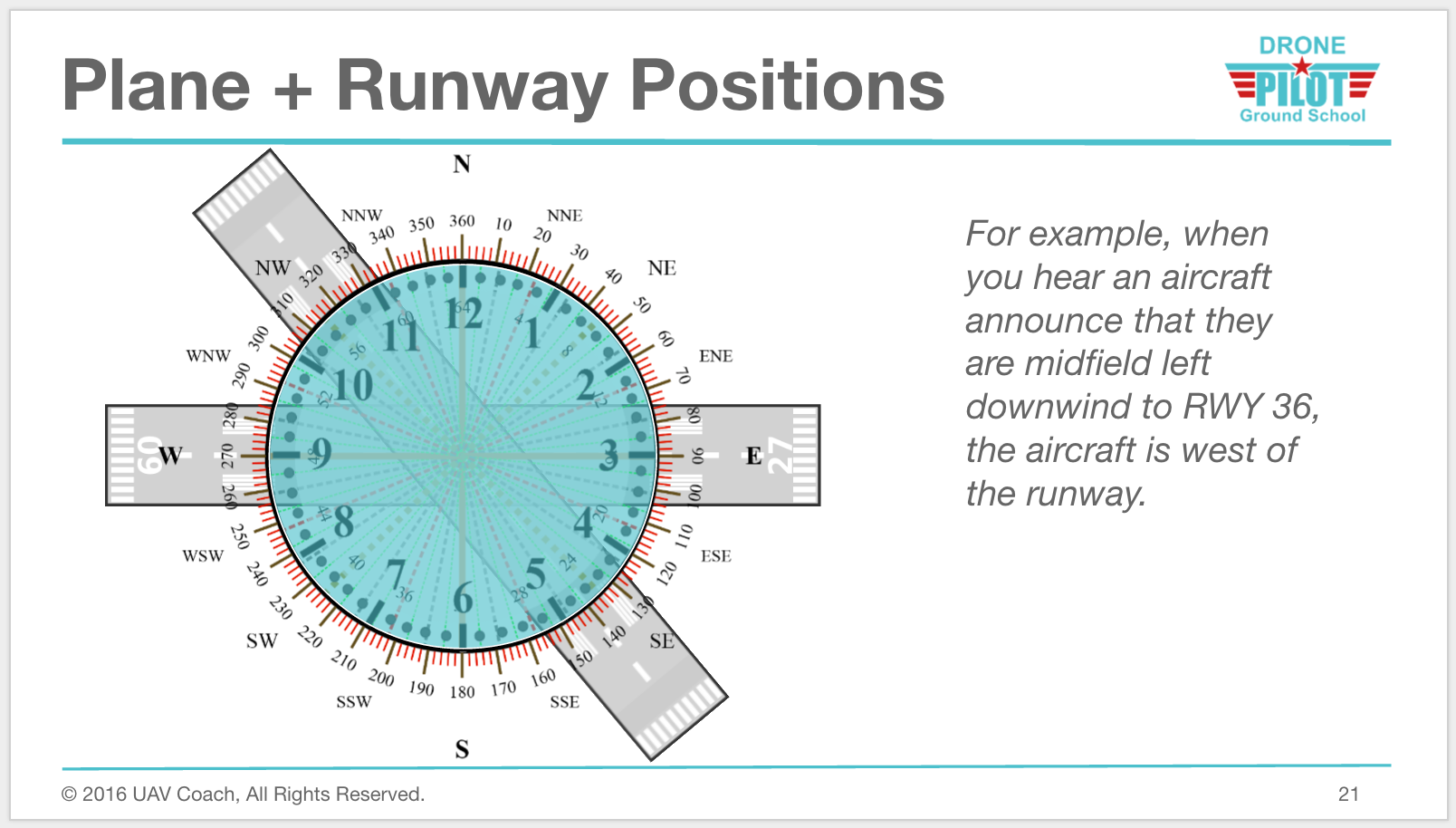
If an aircraft is left downwind of the runway, it means they’re flying parallel to the runway, in the opposite, downwind direction (the runway is to the pilot’s left, hence “left downwind”). So the opposite heading (or 180 degrees from) 160 degrees is 340 degrees. It can be helpful to sketch this type of question out on a separate sheet of paper.
Imagine that the runway in the illustration below is 16 instead of 36, and sketch out the compass orientation to help you answer the question.

3. While monitoring the Cooperstown CTAF you hear an aircraft announce that they are midfield left downwind to RWY 13. Where would the aircraft be relative to the runway?
A) The aircraft is East.
B) The aircraft is South.
C) The aircraft is West.
Similar to the question above, the trick is to know that “left downwind” means the aircraft is flying parallel to the runway, where the runway is to the “left” of the pilot, and the aircraft is flying opposite (or 180 degrees) from the Runway 13 heading of 130 degrees. Again, if you’re having trouble with compass orientation, it can be really helpful to sketch this one out on a blank sheet of paper. Make sure to review the Airport Operations lecture!

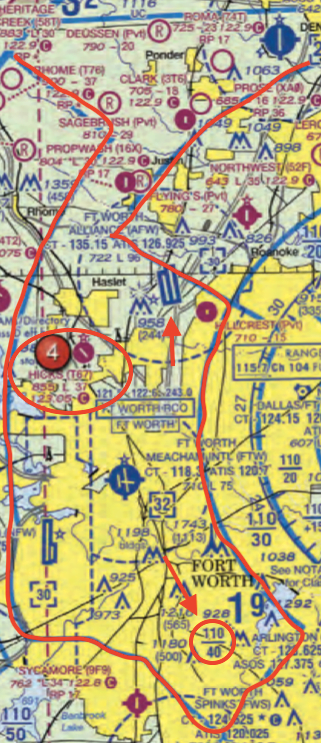
4. (Refer to Figure 25, area 4.) The floor of Class B airspace overlying Hicks Airport (T67) northwest of Fort Worth Meacham International airport (FTW) is
A) 2,000 ft. MSL
B) 3,200 ft. MSL
C) 4,000 ft. MSL
This is one of the most complicated Sectional Chart excerpts you’ll encounter. It’s crowded and difficult to interpret. Take your time to first identify where Hicks Airport (T67) is located. You’ll then want to look for the fraction 110/40 that indicates the ceiling and floor of Class B airspace in that part of the chart. Each section that’s enclosed by the blue solid line has a different ceiling and floor, so scan your eyes inside of the closed space that Hicks Airport sits in.

The 110/40 means that in that part of the chart, the ceiling of the Class B airspace is 11,000 ft. MSL, and the floor is 4,000 ft. MSL.
5. (Refer to Figure 20, area 1.) You’re hired to inspect a group of structures that are under construction 9 statute miles (SM) south of Norfolk Intl airport. What’s the highest you’re allowed to fly without needing to ask for additional FAA permission?
A) 470 ft. MSL
B) 853 ft. AGL
C) 1,200 ft. MSL
While the Part 107 regulations state a maximum altitude of 400 ft. AGL, you’re allowed to fly higher than that as long as you’re within 400 ft. of a tower / obstruction. You’re even allowed to fly up to 400 ft. over the topmost part of that tower. In this case, the height of the high-intensity lighted group of structures under construction 9 statute miles (SM) south of Norfolk Intl airport is 453 ft. AGL. If you’re flying “as high as allowed under Part 107,” you’d be flying 453 ft. AGL + 400 ft., or 853 ft. AGL.
6. (Refer to Figure 80.) What minimum elevation should a manned aircraft pilot fly to clear all obstacles in the quadrant surrounding Montrose Rgnl (MTJ)?
A) 5,759 ft. MSL
B) 10,900 ft. MSL
C) 11,700 ft. MSL
After locating Montrose Rgnl (MTJ) airport, you need to look around it to identify the quadrant that it’s in. The airport info text spans two quadrants, but the airport icon is in the top right quadrant. Then, look for the Maximum Elevation Figure (MEF) in that quadrant. It’s a big number 11, and a little number 7. The large number represents thousands of feet MSL. The small number represents hundreds of feet MSL. So that’s where we are getting 11,700 ft. MSL
Remember that the MEF is the minimum altitude that you can fly in a given quadrangle and still be able to clear all obstacles in that quadrangle, including terrain and obstructions. The maximum elevation is rounded up and then another 100 ft. is added.
7. (Refer to Figure 76) What’s the minimum altitude / lowest elevation of the area depicted by the blue line labeled V71?
A) 700 ft. AGL
B) 1,200 ft. AGL
C) 3,500 ft. AGL
The blue lines are Victor Airways. On a Sectional Chart, these show up as thick, faded blue lines that run between either two VHF omnidirectional range (VOR) stations, or a VOR and a VOR intersection.
Victor Airways are identified by a number, similar to an interstate highway. Victor Airways are always designated as Class E airspace and extend from a base of 1,200 ft. AGL up to 18,000 ft. MSL.
That’s why the minimum altitude / lowest elevation as asked in this question will be 1,200 ft. AGL.
8. (Refer to Figure 76.) What is the CTAF frequency at Pierre Rgnl airport (PIR)?
A) 119.025
B) 122.7
C) 122.95
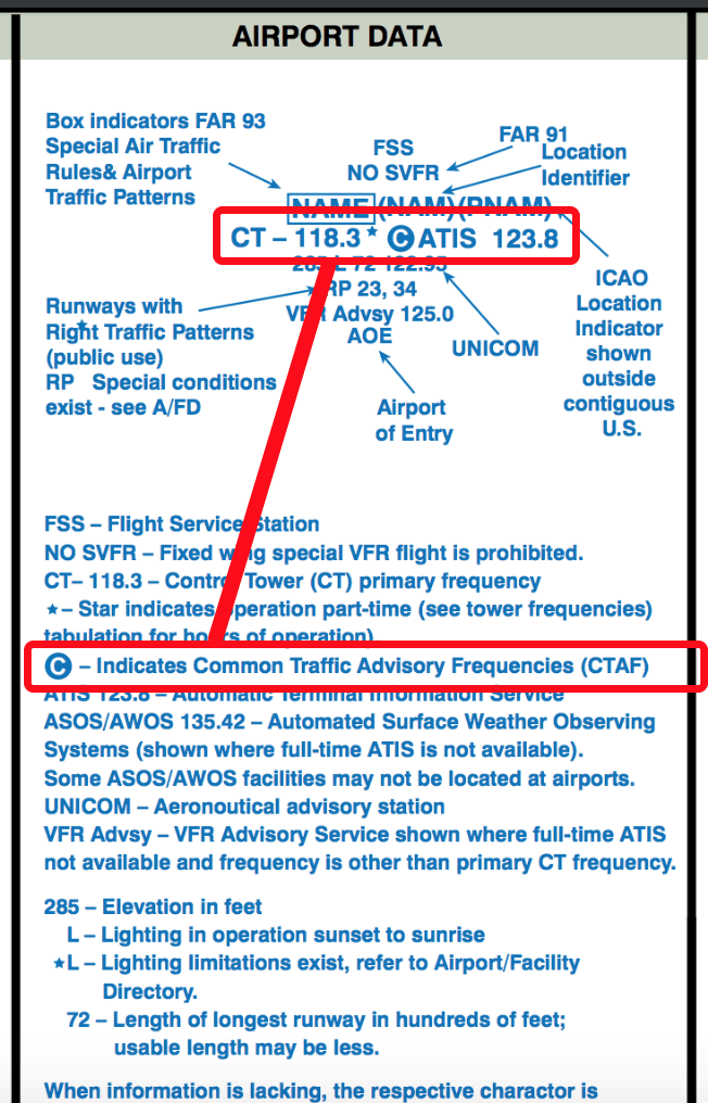
After locating the Pierre Rgnl airport (PIR) icon on the chart, look for the airport information text next to the icon. Remember that in the testing supplement legend, you’re actually being told exactly where a lot of information is on the Sectional Chart. In this case, if we want to find the CTAF frequency, we can consult the legend:

The CTAF frequency is always going to be to the left of the circle C icon. In the legend section above, the CTAF frequency is also the CT or Control Tower frequency, and it is 118.3.
In this question, the CTAF frequency is 122.7.
9. (Refer to Figure 21) What type military flight operations should a pilot expect along IR644 in the Devil’s Lake West MOA?
A) IFR training flights above 1,500 feet AGL at speeds in excess of 250 knots.
B) VFR training flights above 1,500 feet AGL at speeds less than 250 knots.
C) Instrument training flights below 1,500 feet AGL at speeds in excess of 150 knots.
A Military Training Route (MTR) is used by the military for conducting low-altitude, high-speed flight training. Typically, the routes above 1,500 ft. AGL are flown under instrument flight rules (IFR), and the routes flown under 1,500 ft. AGL are flown under visual flight rules (VFR).
On a sectional chart, MTRs are identified as IFR (IR) and VFR (VR), followed by a number. All of this information is displayed on a straight line, with an arrow.
- MTRs with four numbers denote routes flown at 1,500 ft. AGL and below. At such a low altitude, this can present challenges to an unmanned aircraft.
- MTRs with three numbers denote routes flown with at least one segment above 1,500 ft. AGL.
10. (Refer to Figure 69.) What is the ATIS frequency at Corpus Christi Intl airport (CRP), and what is ATIS used for?
A) 119.4, and ATIS is a nongovernment air/ground radio communication station which may provide airport information at public use airports where there’s no tower or FSS
B) 126.8, and ATIS is a continuous broadcast of recorded aeronautical information in busier airports
C) 122.95, and ATIS is a continuous broadcast of recorded aeronautical information in busier airports
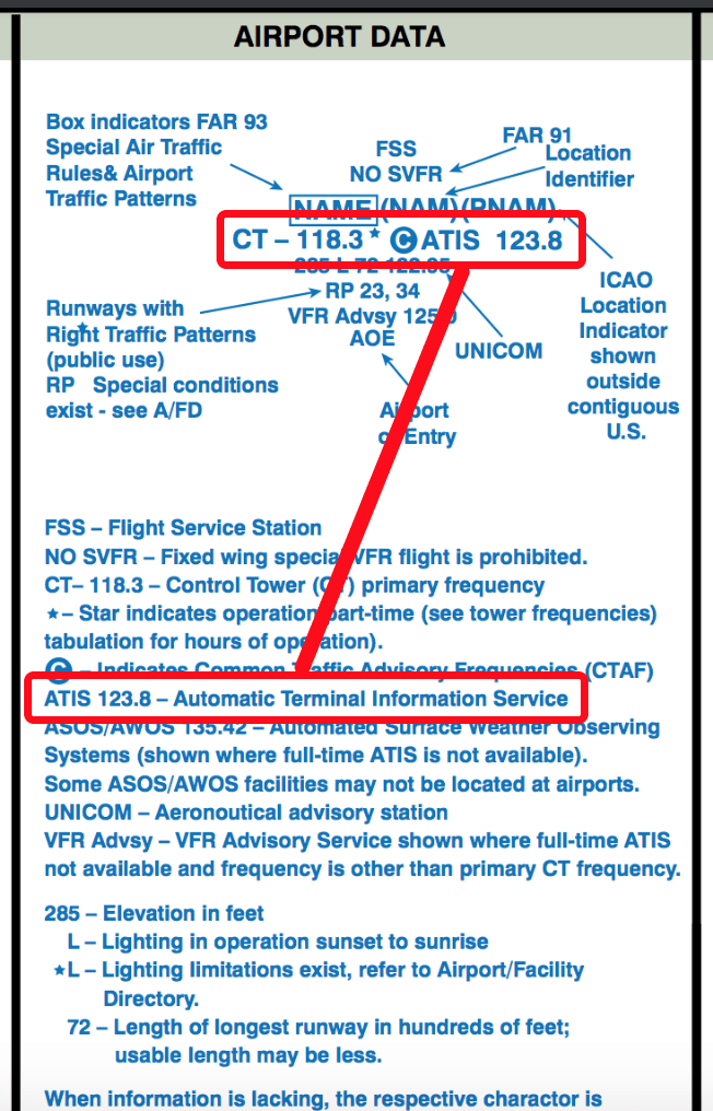
ATIS broadcasts, which are typically broadcast over a discrete very high frequency (VHF) radio frequency, contain essential information, such as weather information, active runways, available approaches, NOTAM, and any other information required by the pilots. Pilots listen to ATIS broadcast information before contacting the local air traffic controller, in order to reduce the controllers’ workload and to prepare their flight.
After locating the Corpus Christi Intl airport (CRP) icon on the chart, look for the airport information text next to the icon. Remember that in the testing supplement legend, you’re actually being told exactly where a lot of information is on the Sectional Chart. In this case, if we want to find the ATIS frequency, we can consult the legend:

Looking back at Figure 69, the ATIS frequency at Corpus Christi Intl airport (CRP) is 126.8.
11. (Refer to Figure 20) You’re asked to inspect the high-intensity lighted tower 12 statute miles SE of Lake Drummond. What’s the highest you’re allowed to fly under Part 107 (as long as you operate within 400 ft. of the tower at all times)?
A) 779 ft. MSL
B) 1049 ft. MSL
C) 1436 ft. AGL
While the Part 107 regulations state a maximum altitude of 400 ft. AGL, you’re allowed to fly higher than that as long as you’re within 400 ft. of a tower / obstruction. You’re even allowed to fly up to 400 ft. over the topmost part of that tower. In this case, the high-intensity lighted tower 12 statute miles (SM) southeast (SE) of Lake Drummond is 1,036 ft. AGL. If you’re flying “as high as allowed under Part 107,” you’d be flying 1,036 ft. AGL + 400 ft., or 1,436 ft. AGL.
12. (Refer to Figure 26, area 5.) The airspace overlying and surrounding a 5 mile radius from Barnes County Airport (BAC) is
A) Class E airspace from the surface to 1,200 feet MSL.
B) Class D airspace from the surface to the floor of the overlying Class E airspace.
C) Class G airspace from the surface to 700 feet AGL.
Barnes County Airport (BAC) sits within a thick, magenta vignette / circle, which indicates Class E airspace starting at 700 ft. AGL. Up until 700 ft. AGL, it’s Class G uncontrolled airspace. Technically, if you were operating an sUAS close to the airport, you wouldn’t need additional permission / authorization as long as you are flying under 700 ft. AGL.
13. (Refer to Figure 26) Which airport is located at approximately 46.93°N latitude and 98.02°’W longitude?
A) Cooperstown
B) Jamestown Regional
C) Barnes County
There are a few things to remember about latitude and longitude on a sectional chart:
- That one degree can be divided into 60 minutes.
- That, as you move west or left, away from the prime meridian, the longitudinal degree numbers go up.
- That, as you move north, away from the equator, the latitudinal degree numbers go up
- That the opposite is true if you’re moving toward the prime meridian or equator.
- That each line of latitude or line of longitude is 30 minutes, or half a degree, from the next one. This is confusing to many students.
So if you’re looking a line of longitude that’s 98 degrees…and you move left…
- The numbers are going up since you’re moving away from the prime meridian
- Each notch to the left is one minute
- Therefore the line to the left, or west, of 98 degrees, is 98 degrees and 30 minutes.
This question is a little tricker, because instead of degrees and minutes, we’re getting degrees and decimals. So you have to know how to translate 46.93°N and 98.02°W back into degrees and minutes.
Since there are 60 minutes in one degree, the calculation becomes 0.93 x 60, or .02 x 60.
So 46.93°N latitude and 98.02°W longitude become 46 degrees, 56 minutes latitude and 98 degrees, 1 minute longitude. With this logic, you should be able to figure out that 46.93°N latitude and 98.02°W longitude indicates Barnes County Airport.
A lot of students struggle with this, so you’re not alone.
###
Good luck to those of you studying to take your Aeronautical Knowledge Test!
Many of you have reached out to [email protected] or called us at (888) 626-1490 with your questions.
Keep them coming.
As a reminder, while our primary goal is to get you to pass your Aeronautical Knowledge Test, we do hold our students to a higher standard and issue a Course Diploma to those of you who complete our flight proficiency challenge. Those of you who’d like to further develop your drone pilot skills and knowledge can also inquire about our hands-on drone flight training classes.

